
Equipment
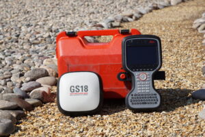 Leica GS18T
You no longer need to hold the pole vertical to level the bubble with the new Leica GS18 T, the fastest and easiest-to-use GNSS smart antenna and RTK rover. This latest innovation combines GNSS and inertial micro units (IMUs) to be the first true tilt compensation solution immune to magnetic disturbances and is calibration-free.
As you no longer need to watch and level the bubble, you can focus on your task at hand and save time over conventional surveying practices. Uninterrupted, accurate positioning when surrounded by or in close proximity to metallic objects – measure where others simply couldn’t before. The GS18 T works directly out of the box without any calibration procedure.
ENGAGING SOFTWARE
The Leica Captivate field software is the perfect companion for the GS18 T. With easy-to-use apps, all measured and design data can be viewed and used, providing you with a clear understanding of your data in 2D and 3D view. Captivate spans industries and applications with little more than a simple tap, regardless of whether you work with GNSS, total stations or both.
TILT COMPENSATION
Based on sensor fusion of IMU and GNSS, GS18 T’s tilt compensation is immune to magnetic disturbances and it works immediately without calibration. With the GS18 T, surveyors have the flexibility to measure points with a levelled pole and still save the tilt values of each measurement. That way you have the trust that what was measured, is correct.
4G LTE & EXCELLENT MEASUREMENT QUALITY
Tracking multi-frequency signals comes as standard with all Leica Geosystems GS sensors. Combined with an excellent GNSS antenna element and a position update rate of 20 Hz, GS18 T ensures reliable measurement quality.
INTERNAL MEMORY
Users with any GS18 model have the flexibility to log raw data into an SD card or the internal memory.
IMPROVED PERFORMANCE
Multipath reduction and interference mitigation options in Captivate boost GNSS signal tracking quality under harsh environments, which improves RTK availability and accuracy. Also, an interference toolkit will enable filtering to remove in- and out-of-band distortions for even more robust GNSS signal tracking.
ACTIVE CUSTOMER CARE
Through Active Customer Care (ACC), a global network of experienced professionals is only a click away to guide you through any challenge. Control your costs with a Customer Care Package (CCP) which gives you peace of mind you are covered anywhere, anytime.

Juniper Geode
Looking for a simple sub-meter GNSS solution at an affordable price? With the Geode, you can easily collect real-time, sub-meter GNSS data without the huge price tag or complexity of other precision receivers.
Designed with versatility in mind, the Geode works with iPhone and iPad as well as a wide range of Windows®, Windows Mobile, and Android™ devices and is especially useful for bring-your-own-device workplaces.
Take the Geode with you mounted on a pole, in a pack, or held in your hand to collect real-time sub-meter GNSS data in harsh environments, using almost any handheld device.
Ground Penetrating Radars
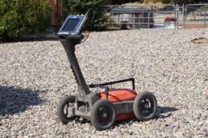 GSSi Utility Scan HS350D with SIR4000 Controller
The UtilityScan features a wireless and lightweight configuration, our patented HyperStacking technology for unparalleled data quality, and integrated LineTrac system. This state-of-the-art system sets the new standard in performance and price.
The new tool for underground utility locating
Compact and Portable
The UtilityScan system is incredibly compact. Weighing in at only 34 pounds, UtilityScan can collapse to fit in the back of a small vehicle or even in an airline overhead compartment. The system also features an adjustable handle with dual pivot points for ease of use.
Premium Features, Entry-level Price
The ideal underground locator – achieve greater depth penetration and clearer data with patented HyperStacking Technology. The UtilityScan features real-time data presentation and gain control, all packaged in an accurate GPR unit.
Advanced Capabilities
UtilityScan comes standard with an internal GPS, or can be integrated with a user provided GPS. This system has an option to add the LineTrac power detection module. LineTrac allows users to detect AC power and induced RF energy present in buried utilities.
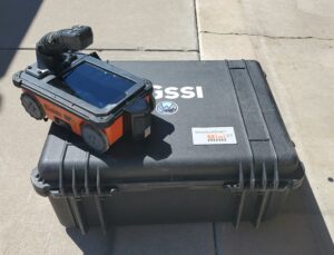 GSSi Structure Scan Mini XT
The StructureScan™ Mini XT is the tool built to handle all your job site and survey needs. This rugged system is designed with an integrated display for single operator data collection and interpretation. Reduce safety risks, financial exposure, costly delays and provide the full-range of services to your customers by adding this concrete scanner to your toolbox.
The Mini XT is ideal for concrete inspection and evaluation. Easily and accurately locate the position and depth of metallic and non-metallic objects in concrete structures, including rebar, conduit, post-tension cables, pan decking, voids and service utilities.
The Professional Scanner’s Choice
High Frequency, High Resolution Concrete Antenna
The StructureScan Mini XT employs a 2.7 GHz antenna that provides excellent near surface resolution while also maintaining the ability to resolve deeper targets.
Enhanced Target Visualization
The StructureScan Mini XT provides multiple modes for data collection and interpretation:
- Scan EZ: With the press of just one button, this mode provides the ideal amount of information with 2D data views for efficient mark-and-go surveys
- Scan Max: Focus mode is designed to simplify the data to better highlight embedments, locate voids and see closely spaced targets
- Scan 3D: 3D visualization is often used in complicated structural scenarios where the survey area may contain multiple levels of targets. This mode helps the user visualize congested areas and non-linear targets
Increase Job Site Efficiency with Mini XT Kit
Today’s professional scanners need a variety of tools to conquer all job site obstacles. For large survey areas the extension pole allows for better ergonomics and ease of use. Using the Mini XT harness and Palm XT antenna together allows the user to collect data with one-hand operation ensuring you maintain 3 points of contact to comply with OSHA regulations.
Electrical Resistivity
 SuperSting WiFi R8 with a 56-electrode switchbox
The SuperSting™ Wi-Fi is a next-generation electrical resistivity meter and induced polarization (IP), and self-potential (SP) system, used to scan and image the subsurface of the earth and visualize the results in 2D slices or 3D volumes. The fully automated SuperSting™ has been thoroughly field-tested on every extreme environment on earth, utilized in over 700 peer-reviewed journal articles, and provides the highest accuracy and lowest noise levels in the industry. The SuperSting™ line of electrical resistivity tomography equipment is the first in the industry to have multi-channel capability and is continually improved and updated with additional features. With the included tablet, you can control the SuperSting™ Wifi from up to 100m away!
There are five models of the SuperSting™ available (which can be upgraded simply from anywhere in the world by use of a license code):
- R1 (single channel)
- R2 (two channel)
- R4 (four channel)
- R6 (six channel)
- R8 (eight channel)
Custom made 1.2-meter-long (48 inch) electrodes designed for arid soils
Borehole Camera
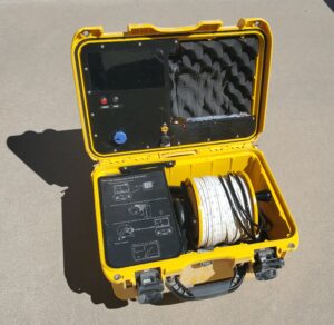 Heron Instruments Adventurer See 150 with 45.7-meter (150 foot) tape
A compact, but powerful inspection camera
- For crystal clear real-time viewing in holes 1″ (25mm) & wider
- All-In-One, Portable & Affordable
- Built-In – 600×1024, 7” (177.8mm) monitor (inside case) for clear & quick inspections
The dipper-See ADVENTURER comes with everything you need to perform a quick and hassle-free well inspection. Ideal for shallow wells, the ADVENTURER helps users obtain a real-time view of what is happening in the well or borehole.
The dipper-See ADVENTURER is an ideal tool for monitoring the well’s overall functionality or condition while also checking for cracks in the casing. Hydrogeologists and others performing well inspections love the underwater camera for its ease of use and compact size.
Utility Locator
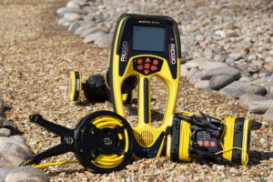 Ridgid SeekTech ST305 Transmitter
The 5 watt SeekTech ST-305 Line Transmitter lets you energize metallic lines for tracing.
- Lightweight and compact transmitter that delivers up to 5 watts of power.
- Can transmit two frequencies simultaneously.
- Audio feedback confirms a good circuit before beginning a trace.
Ridgid SeekTech SR60 Locator
Choose the SR-60 locator for fast confident locates even under tough locate conditions (poor conductors, poor soil conditions, poor grounding, etc.).
- Trace any frequency from 10 Hz to 490 kHz.
- Trace energized lines and sondes (beacons) simultaneously.
- Has all the ease of use and accuracy of the SR-20 but with ALL locatable frequencies.
Unmanned Aerial Systems (UAS).


Magnetometers
Geometrics Portable Proton Magnetometer
 Lidar
Lidar